High res versions are available for prints etc.
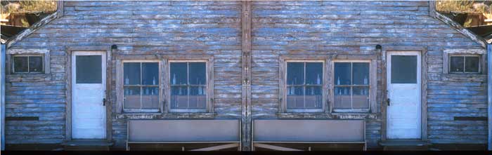
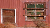
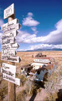
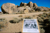
On the final day just enough time to visit Randsberg, a ghost town about 60 miles northwest of Barstow. If you like peeling paint, weathered wood, rust, old bottles then you'll have a ball. Good place to test your creativity and powers of observation.
DAY 21
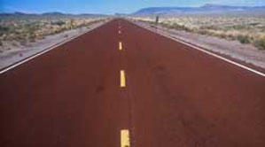
After an hour or so here it was back onto Route 66 and then onto Barstow for the night with one full day to go.
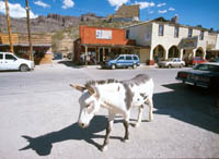
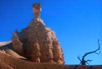
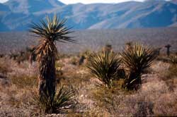
Later climbed up through the Black Mountains to visit the ghost town of Oatman. Some Ghost town ! An old mining town full of visitors, wild burros roaming the main street, old buildings, gift shops etc. in the middle of nowhere. The adobe style Oatman Hotel top right of the picture was where Clark Gable and Carol Lombard honeymooned in 1930's.
DAY 20
Continued along Route 66 and stopped many times including one at Hackberry (NE of Kingman) to visit the Old 66 Visitors Centre. Bob Waldmire (on right) who ran the centre is now in Illinois. His great work at the centre will be carried on and its a fascinating place to visit.
DAY 19
All good things come to an end and this was the first day of the return journey. South through Flagstaff - almost unrecognizable from when I stayed there in 1982 and onto Sedona but the roads were really busy and after a couple of stops for fall colour it was back to Route 66 to see how far I could get before nightfall. Eventually I stayed at Seligman and remaining on Route 66 was much more interesting than charging along Route 40. An overnight storm was just clearing next morning as I left Seligman so it was a good opportunity for some sky pictures.
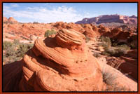
After a good session I visited the hoodoos near Paria Canyon and by accident bumped into the same group of UK photographers I had met several days earlier. This area looked really interesting and has potential. Alas I only had 45 minutes or so before the light finally went.
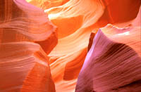
Onto Page and this time to Lower Antelope which I had not visited before. I thought it was better than the other one on several counts. The lighting is better earlier in the day, it was a great deal quieter and in many ways more photogenic than Higher Antelope.
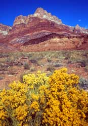
I decided to return to Page a slightly different way via Fredonia and the Vermilion Cliffs. There was a little more variety enroute and I stopped several times for images of trees, mountains and close-ups
Day 18
room had not been made up. I was less than pleased and following an exchange of views on the situation I got a refund and left immediately for Page. I got as far as Mount Camel and stayed at the Golden Hills. A good hot bath and an excellent meal were just what was needed to raise the spirits after the downer at Fosters.
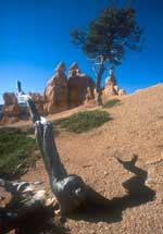
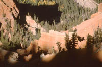
It was pretty chilly early on - freezing in fact but once the sun came up and warmed our hands and hearts I decided to do a long walk down the canyon exploring Queens Drive and Navajo Loop trail before ending up climbing back to the top via Wall Street.
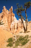
When you start exploring below the rim,
you'll find much to photograph. The shapes and patterns of the rocks and trees
will keep you busy for hours.
By 4-00 pm I was quite tired and ready for a
hot bath prior to a sunset session, so I headed back to the motel. However on
my return I found the room door wide open and the
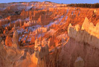
Early morning at Bryce to catch the sunrise and as there had been some snow a few days previously the extras bits of white enhance the final effect
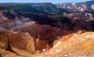
DAY 17
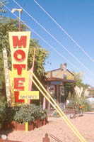
Whilst in Page I stayed at the excellent Bashful Bobs Motel which is ideally placed for visits to Antelope and the area and the owner Robert Wombacher is more than helpful - you can reach him at bashfulbobmotel@webtv.net
I reached Bryce just in time for a few sunset pictures though on booking in at Fosters Motel I found my room had not been made up from the previous occupant and there was worse to follow the next day.
Sunshine again and a morning in Upper Antelope before heading north to Bryce. Probably the most photogenic of all slot canyons, Antelope Canyon has two sections. North of highway 98 is Lower Antelope which has a very narrow entrance but at least you can reach it easily from the car park by foot. The arrangement is different at Upper Antelope. After paying 5 dollars for your permit you pay for the ten minute ride to the entrance by the hour with a maximum of 15 dollars. I am afraid Upper Antelope has become very popular and almost every hour there are tour parties often firing off flashes indiscriminately and sometimes appearing in serious photographers long exposures !
http://www.fatali.com
DAY 16
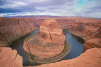
Today I had a prearranged meeting at Antelope Canyon with a group of photographers from England who had just arrived in the area. Alas the weather had changed and the sun was nowhere to be seen. As a trip down the canyon would have been a waste of time photographically we decided to visit the 'horseshoe' viewpoint a few miles away to check out the lighting conditions.
DAY 15
It was a great but extremely tiring day. Next time I'll be better prepared.
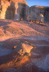
Big day today - the one the whole trip was organized around. Its the day I have a permit to visit the 'waves' a protected area between Page and Kanab near Buckskin Gulch. To protect this wilderness only 8 permits are issued each day so normally one has to book at last six months in advance.
DAY 14
T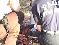 hey
can be dangerous too. A year or so ago eleven people were killed at Lower Antelope
due to a flash flood. The only survivor Pablo, a tour guide can be seen being
attended to by members of the rescue team. I am indebted to Bob Wombacher for
this image from the video he shot at the time. I understand two of the bodies
have yet to be found. They are likely to have been washed 3-4 miles into Lake
Powell.
hey
can be dangerous too. A year or so ago eleven people were killed at Lower Antelope
due to a flash flood. The only survivor Pablo, a tour guide can be seen being
attended to by members of the rescue team. I am indebted to Bob Wombacher for
this image from the video he shot at the time. I understand two of the bodies
have yet to be found. They are likely to have been washed 3-4 miles into Lake
Powell.
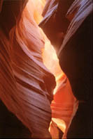
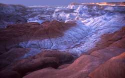
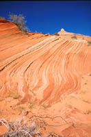
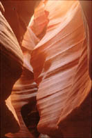
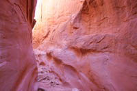
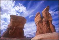
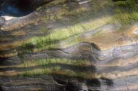
Slot canyons are often very narrow, deep and overhanging. Some are less than a yard wide and drop for over a hundred feet from the rim to the canyon floor. Sculptured by wind and water they feature waves and curls and the effect and colour will depend on the position of the sun, time of day and time of year.
Today started with a long drive down to Page in Arizona, stopping briefly at the Coral Pink Dunes near Kanab. These were very disappointing, the beauty of the dunes having been spoilt by marks left by dune buggies. I arrived in Page early enough to spend the afternoon in one of the Antelope slot canyons. However I did have one major problem. As I was taking the photo gear out of the rental car I accidentally knocked the keys onto the backseat and a gust of wind closed the door locking everything inside. Great!!! However the Indians who run the Slots organized a locksmith from Page and he was there in twenty minutes ! I did get a spare key for my trouble though Alamo rental refused to refund any money at the end of the rental.
DAY 13
Though interesting , it is not nearly as photogenic as the the slots near Page I would be visiting later. I wanted to get to the petrified forest in Escalente before sunset but the trek back to the car took too long though I did manage a shot or two of the locals and some fall images by the lake near the entrance to the forest.
The main reason for coming down this road was to visit one of the slot canyons in the Dry Fork Coyote Gulch area. A further 14 and a half miles from Devils Garden you turn left down an unmarked rough road. From the parking lot - a further two miles on - there is a strenuous ( for me very strenuous ) hike down to the bed of the Coyote Gulch. Then on the left you'll find the easiest of the slots in the area - Dry Fork. Others are Peek-a-Boo, Spooky, and Brimstone. Below is a typical view down Dry Fork.
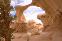
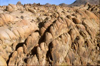
Off to Escalente and down the Hole-in- the- Rock road, five miles east of the town. Its a dirt and sometimes rough road and after 12 miles you get to Devils Garden. There are some interesting rock formations and it is definitely worth a stop for an hour or so.
DAY 12
I spent an hour or so here before the long
drive via Zion Canyon to Escalente. Managed to shoot a mixture of stuff on the
way before arriving at Tropic - between Bryce and Escalente. I stayed in the excellent
Stepping Stone Motel.
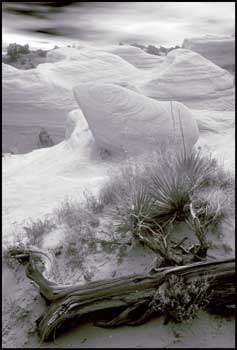
The left-hand image of the two shots below was shot
on black and white infra red film
DAY 10
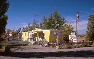
Glendale was ideally placed as a starting off place for my journey to Area 51 and in particular the small town of Rachel. A drive of 80 odd miles to reach the ET Highway (route375) through typical Nevada desert landscape, then a further 35 miles before reaching Rachel, not really a town , more a collection of mobile homes
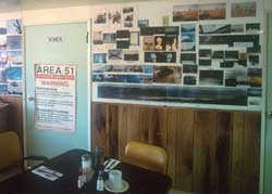
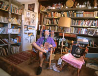
For those interested in staying a while
there is a place to stay and eat - the 'Little A'Le'Inn'-I can recommend the fruit
pie !. There are also souvenirs to buy and as you can see- above left - plenty
of UFO pics to look at. Another place to visit is the Area 51 Research Centre-
above right. Plenty to see and souvenirs to buy at the Centre run by Glen Campbell
-web site
http://www.ufomind.com
For
those planning to visit the area a copy of the area 51 Viewers guide is more than
useful - details from the above site- you can get it by mail order.
On the
way back I stopped at the infamous mail box where many 'sightings' have been reported.
No luck for me though !!
An interesting day ended with a 400 mile drive across Nevada into Utah and Cedar City and the motel.
DAY 11
On the road early for Cedar Breaks. This was my first visit here and I found it quite small in comparison to Bryce. It didn't quite have the variety of Bryce though as the sun was finding its way into the canyon I did take a few pictures - the ones below of patterns of light taken with 18 and 180mm lenses
I stayed longer than planned before I drove
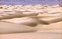
to Death Valley and the sand dunes at Stovepipe Wells. As I had sacrificed the
best light to stay at the Alabama Hills I did not stay too long at the dunes.
I love the desert but I had spent several days here in 82 and to get the best
pictures you do need low lighting to bring out the lovely shapes.The shot on the
left was taken with a 180mm lens.
I had planned to stay in Las Vegas and move
onto Area 51 the next day but expensive motels and roadwork's were factors in
deciding to press on a bit further to a good motel in Glendale. In all a cracking
350 mile day- albeit a bit tiring.
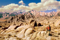
Another early start ( what's new ) to reach the Alabama Hills before dawn to catch the first light on Mount Williamson. Reached the spot I had chosen the previous evening to find a John Wayne 'look-a-like' down for the movie weekend nearby. The image below has been manipulated in Photoshop. JW was moved to a new position, clouds were added and the scene was warmed up.
DAY 9
road which may be tough going. Perhaps I'll try that route another year. There was just enough time to get back to Bishop Creek for more fall colour pictures. Though I did manage a few my efforts were foiled by a holdup on a narrow dirt road by the delivery of a portable WC !!!!
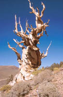
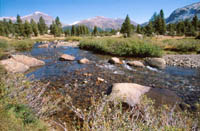
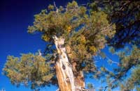
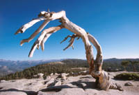
If you head east from Big Pine on the 168 and then north on the White Mountain road you'll come to the Bristlecone Pines. You'll be climbing upto 10,000 ft and the road is quite narrow so take care. There are two main groves - Schulman and Patriarch. I only had time to go to the former. These pines have lived for 4000 years
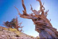
The interesting shapes and patterns they provide for the photographer are well worth the journey.
Allow plenty of time for the walk around the grove which is hilly at times. The Patriarch Grove is a further 11 miles along a single dirt
I had missed first light on Mount Williamson so I spent a few hours taking pictures and searching for a good location for another attempt the following day before heading north to the White Mountains and the Bristlecone Pines
A really early start to get to the Alabama Hills near Lone Pine before dawn. The Alabama Hills- images below - used to be used as locations for movies years ago including such classics as Gunga Din and Wagon Train. My visit coincided with the yearly movie weekend so all the motels in the immediate vicinity were fully booked so I had to stay in Bishop some 60 miles away. The organizers of the special weekend had placed plaques at each film location to show film buffs the exact spot of location shots. The image below right illustrates a location for Mule train shot in 1950.
DAY 8
A useful book covering the Eastern Sierra
area is the 'Photographers Guide to the Eastern Sierra ' by Carol Leigh
-details on her web site http://www.calphoto.com.
There
you will also find details of the Fall hotline and web page.
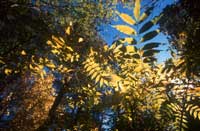
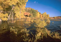
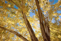
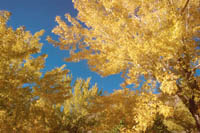
Timing a visit to this area to catch the best of the autumn colours is a bit tricky and I was about a week early. The colours vary according to the weather conditions and height above sea level. I did manage a fair number of reasonable images of the colourful aspens two of which are above. Two good areas to explore near Lee Vining are Lundy Canyon and the Juno Lake.
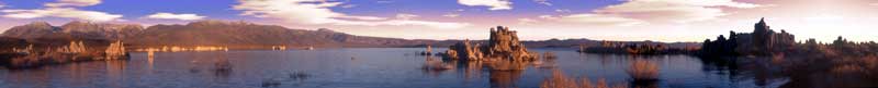
The dawn panorama of Mono lake was made up from 7 individual images and pasted together in Photoshop
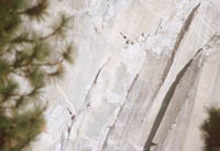
The arrows on the picture on the telephoto
shot on the right pick out the climbers.
The rest of the day was spent exploring
the beauty of the valley. The Yosemite Falls was quite disappointing due to a
lack of water. Sunset at Tunnel View and then back to Mariposa. Yosemite is a
very popular place and motels etc. Even those 50 miles away get booked up well
in advance so book early.
DAY 6
1-800-427-7623
Allow plenty of time as the route is very photogenic especially the area around Tuolimne Meadows - below
I got to Lee Vining earlier than expected so there was time to spend a few hours at Bodie, a great ghost town an hour or so north of Lee Vining. The road is not good and may well be impassible at times. The late afternoon light was excellent and brought warmth to the old timber buildings. Some shots look just as attractive in black and white and the transfer in Photoshop is easy
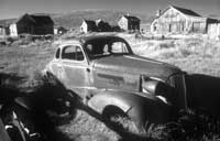
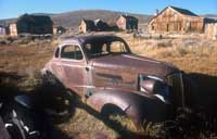
I had visited Bodie back in 1982 and I wondered whether much had changed. On checking some of the old images I noticed many similarities even in the interiors. Check out the two shots below and note the folds in the table cloth
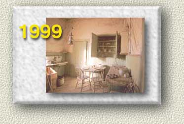

Not much had changed after 17 years. Anyway the lighting was so good I stayed far too long and missed the sunset at Mono lake
DAY 7
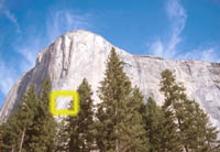
Up early again and departure before 6-30 from Maripusa for dawn shots at Tunnel View. Plenty of tripods in evidence as photographers of different nationalities gathered to capture the early morning light. I later watched and caught on film the group of climbers attempting the near vertical face of El Capitan --and they do it for fun!
DAY 5
The picture on the left was taken just before one reaches the pine. The sky which was added later in Photoshop was shot earlier that day. Heading back to the car into the dying sun I missed the trail and got lost for an hour. Fortunately I didn't bump into a grizzly or bigfoot!!
Early start again and a longish journey
to Yosemite. Because of road construction work on the El Portel route the road
was closed to all traffic during the day so from Mariposa where I was staying
I had to enter the Park via the southern entrance on Route 41. Just before the
entrance is the Yosemite Mountain Sugar Pine railroad. Worth a visit for some
pictures of the steam loco.
Next stop was the Mariposa Grove of giant sequoias
which is about 35 miles from Yosemite Valley. I spent an hour so taking pictures
here before moving towards Glacier Point. At marker G8 on Glacier point road is
the parking place for the mile walk to see the famous Jeffrey Pine at Sentinel
Dome. Time was getting on and I managed to get some pictures before the sun finally
went down.
Day 4
Between December and May you may be lucky enough to see gray whales. It was a bit too early for me so by 4-0 pm I was off to Monterey to visit the famous Aquarium. As time was limited I stuck to video and got some lovely footage of the jelly fish - beautifully housed in a big tank. The examples below are realvideo files. You may require RealPlayerG2- http://www.real.com
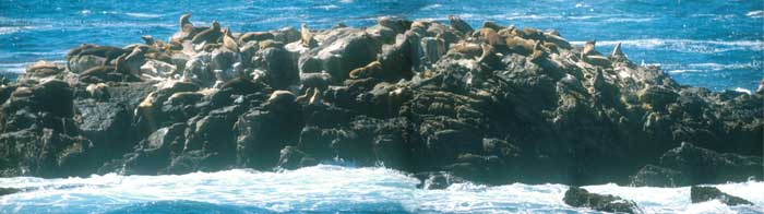
There are plenty of trails to choose from, with plenty of photographic opportunities and a walk down Sea Lion Point trail will take you to telephoto distance of barking Californian sea lions who hold their noisy meetings on offshore rocks. The shot below is a composite of two 300mm shots merged in Photoshop.


An early morning start and drive to Point
Lobos on the coast. This area was made famous by Ansel Adams - who I was fortunate
to meet many years ago and Edward Weston.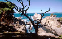 The Park does not open until 9-00 am so I was an early bird being third in the
queue when we were allowed to enter. The weather was quite warm even at that time
in the morning so with plenty of gear to carry and a lot of walking to do it was
going to be a tough day and so it proved.
The Park does not open until 9-00 am so I was an early bird being third in the
queue when we were allowed to enter. The weather was quite warm even at that time
in the morning so with plenty of gear to carry and a lot of walking to do it was
going to be a tough day and so it proved.
Point Lobos has been part of the
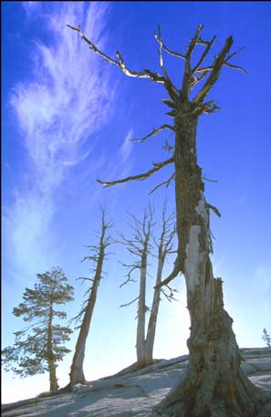
US park system since 1933 and is a great source of photographic material. The
artistically twisted Monterey pines and Cypress make it a place to remember.
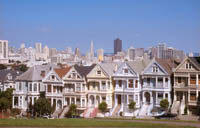
DAY 3
Not many pictures today, just a trip to
Alamo Square ( pics below ) and some video on Ocean Beach watching the Pacific
rushing in (You may require RealPlayerG2- http://www.real.com)
It was an excellent relaxing start to the trip. However the first blip of the
stay was near at hand. After a late afternoon drive to Hollister and the Cinderella
Motel I was rather put out to discover they had lost my pre-booking and
the the motel was full !
However a Best Western motel nearby saved the day
but a definite black mark to the Cinderella !!

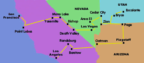
As you will see from the above map it was quite a long trip lasting three weeks with quite a few highs and a few lows. The flight via Newark from Manchester ( UK ) to SF was delayed quite a bit so combined with a wait for my hire car I set off to my first motel quite late. Luckily it turned out to be only a block away so my driving skills were not to be tested that first evening. The changeover in Newark was an opportunity for a few pictures and as you can see below you get a view of the New York skyline from Newark airport.
DAY 1