


first
became interested in digital landscape programmes quite a few years ago when I
was using an Amiga 2000 and the very first programme I came across was Scene
Generator from Natural Graphics in 1989- I have the original 12 page
manual in front of me. Now ten years later there is a new programme from the same
software designer - Natural Scene Designer 2.0
which is available for both Mac and PC. Details from
http://www.naturalgfx.com
About
the same time -about ten years ago came the early version of Vistapro
for the Amiga - Vista 1.0 from Virtual Reality Labs- the manual went to 40 pages
- wow ! The specs were pretty basic in those days. In 1992 Vistapro2
for the Amiga was launched. Animation was pretty basic but we did have trees !
A year later came Vistapro3 with versions for both the PC and Amiga with
major improvements. At this time Vistamorph came out which added to the excitement.A
few years later Vistapro4 hit the streets
but with a new distributor . We lost the morph and makepath extras and there are
no signs of any further advancements to the programme at the moment. The main
landscape generators these days are the five at the top of the page and there
will be examples on the relevant pages.
Other programmes are as follows
AMAP landscape modeling application - includes
Genesis plant growth programme which is very
extensive but also very expensive. Genesis
is also available as plug-ins for Maya and Softimage. Trees and plants can also
be exported as DXF, LWO, OBJ and 3DS. Details from
http://www.jmg-graphics.com
3D
Landscape Navigator - Kashmir 3D
http://www.kt.rim
Mountain
3D
http://www.cjain.free.fr
GenesisII
http://www.geomantics.com
TruFlite
http://www.truflite.com
MojoWorld
- new on the scene - demo available from site below
http://www.pandromeda.com
World
Machine - is a new terrain generator. you can export as a 'Ter'
for Terragen or as a TGA for importing into Vue. It has an interesting method
of producing landscapes and the results are very good.
http://students.washington.edu/sschmitt/world/


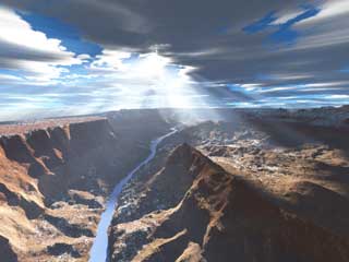
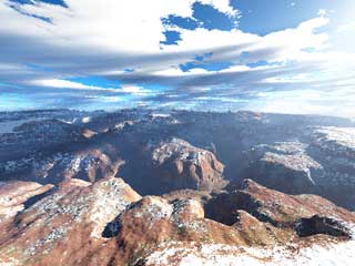
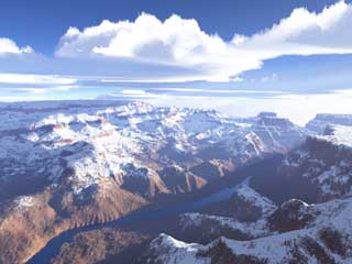
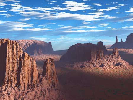
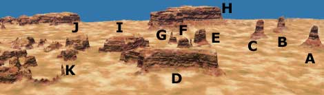
The above images ( put mouse over image for different lighting ) are from the Monument Valley DEM mentioned later on this page. This view is taken from a point just north of Spearhead Mesa looking SW with a 55 mm lens.
Though the DEMs are quite detailed I was disappointed I could not find my tripod marks from when I was there in 1983 ! Ah the ravages of time. To get the DEM into Terragen the original Mitten DEM was loaded into 3DEM (see ref later) and saved as a TER file at 1025 x 1025
Many of the landscape progs have the ability to import objects and trees etc and while some of them have quite a range of trees and plants within the programs there are specialist programs to grow your own !
These
vary in price and specifications
Top of the tree so to speak is Tree
Professional available from Onyx
Computing
Another top performer is Tree Druid
which comes as a plug-in or as a standalone programme. Info from Hutchinson
Avenue Software Corp
A more economical programme is
Tree Factory from MECN Graphics. My copy is some 5 years old so
I don't know whether it is still available and I don't have a web address.
For plants try Plant Studio- http://www.kurtz-fernhout.com.
You can download the demo version for free from the above site and registration
for the full copy will not require a remortgage.
For
architectural 3d trees and plants have a look at Nsight3D
- http://www.nsight3d.com
Yet another plant and tree modeling programme is Xfrog
- http://www.greenworks.de
For those with an unlimited budget have a look at Maya Paint - http://www.aliaswavefront.com/entertainment
DEM STUFF
DEM
(USGS Digital Elevation model) files are digital representations of cartographic
information in a raster form. They consist of a sample array of elevations for
a number of ground positions at regularly spaced intervals.They come in different
sizes - 7.5- minute,15- minute, 2-arc seconds and 1 -degree units. The first two
are in the large scale category, the 2-arc seconds (also known as 30 -minute)
is intermediate and the 1-degree DEM falls within the small scale section. For
more details look at
http://edcwww.cr.usgs.gov/glis/hyper/guide/usgs_dem
Useful
programs
GTOPO30 DEMS can be downloaded from http://edcwww.cr.usgs.gov/landaac/gtopo30/gtopo.html
http://edcaac.usgs.gov/gtopo30/gtopo30.html
1 degree USGS DEMs can be downloaded from http://edcwww.cr.usgs.gov/glis/hyper/guide/1_dgr_demfig/index1m.html
7.5
minute SDTS DEMs can be downloaded from
http://edcww.cr.usgs.gov/bin/maptest/coords=55+-130+20+-65/scale=24/type=dem/zoom=8
Note that the 7.5 ones are downloaded in the *.tar.gz format
There
is a useful conversion tutorial at http://www.cherba.com/wcs.htm
Another
Dem reference site is Map Mart at http://www.terrasource
.net
Wilbur
allows you to import terrain data from many sources
including Bryce, Terragen,
TGA, BMP, PCX, USGS DEM
http://www.ridgenet.net/~jslayton/software.htm
Microdem
displays and merges DEMs and satellite imagery
http://www.usna.edu/Users/oceano/pguth/website/microdem.htm
SDTS2DEM
is a utility to transfer SDTS files to DEM
available from US Bureau of Land
management
Leveller
is an inexpensive terrain/heightfield modeller. A demo is available from
http://www.daylongraphics.com/products/leveller/index.html
programs of interest to users of Terragen
Firmament
used to transfer bitmap and SDTS DEM files to Terragen terrain files (ter)
http://mclusky.cjb.net/firmament
3DEM70
and 3DEM80
used to merge and transfer DEMs to Terregan files
http://www.monumental.com/rshorne/3dem.html